

Winter Storm Xylia accomplished, for the most part, what all the talk was about, becoming the largest two-day storm on record for Denver and the fourth-biggest snowstorm since 1881. Dumping heavy, wet accumulations up and down the Front Range over the weekend, the blizzard halted traffic on the interstates, knocked out power to thousands, and hit a few places especially hard – including 27.1 inches at Denver International Airport, 40 inches near Red Feather Lakes, and 30.8 inches for Cheyenne, Wyo.
Here in Chaffee County, it was a stout storm, but as of Monday morning it was sunny, the lower areas were melting down significantly and Highway 285 was mostly dry through the mid-county after plowing efforts.
The great news was that, according to Open Snow, Monarch Ski Area received a beastly 24 inches (11 on Saturday and 13 Sunday) – the same total as Wolf Creek. Further west, Telluride took bragging rights from the storm with 27 inches. Elsewhere it was hit or miss: Mid-Vail reported a scant 6.
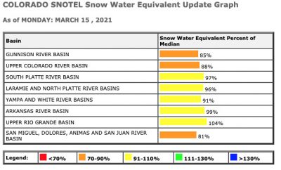
Snowpack improved with the weekend’s big snowstorm. Image SNOTEL/USDA
Xylia delivered some good gains to the state’s snowpack. Portions of the Arkansas River Basin – which includes Chaffee County – saw some of the biggest action from the storm, putting the basin’s snowpack at 99 percent of average, compared to 90 percent recorded March 11.
According to the USDA’s SNOTEL water snow-equivalent reporting systems, the Upper Rio Grande basin is now at 104 percent compared to 98 percent. Percentages in Colorado’s other basins include: South Platte, 97 (was 87); North Platte, 96 (was 90); Yampa and White, 91 (was 88); Upper Colorado, 88 (was 84); Gunnison, 85 (was 81); and the southwest mountains including the San Miguel, Dolores, Animas and San Juan river basins, 81 (were 78).
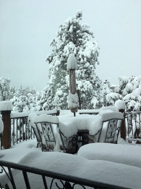
The storm that blew through Colorado this past weekend dumped a welcome amount of heavy, wet snow that is helping (though not totally alleviating) Colorado’s drought conditions. Photo by Jan Wondra.
“The departing storm produced as much as one to three feet of snow in the central Rockies, where spring and summer runoff and water-supply prospects have improved,” the USDA reported Monday in its Agricultural Weather Highlights. “There have been modest snowpack improvements in other drought-affected areas of the West, including the Sierra Nevada, although recent and ongoing snowfall has only slightly reduced longer-term precipitation deficits.”
Crops such as winter wheat on the Eastern Plains saw some badly needed water with the storm. But overall, the long-running drought in Colorado remains in place.
The U.S. Drought Monitor, which is updated each Thursday, last showed all of Colorado as abnormally dry. It rated 56.6 percent of the state as in extreme drought and 15.9 percent as exceptional.
The Drought Monitor (as of March 12) rates 2021 as Chaffee County’s 36th driest in 127 years.


Recent Comments