

With the 2021 Autumn Equinox behind us, now is the perfect time to start looking for leaves. For community members who are wanting to see the colors without roaming too far, the Salida Chamber has released the following list of locations right here in Chaffee County.
Aspen Ridge
This graded dirt road leads to expansive views of the Continental Divide. From Highway 285 along Trout Creek Pass, take County Roads (CR) 307, 187, and 185 to Bassam Park. Those who are up for adventure may wish to continue the trip over the ridge to Salida. Caution, this section can be rough and washed out in places.
Cottonwood Pass
County Road 306, also known as Cottonwood Pass Road, tops out at 12,126 feet and is paved the entire way. During summer this route can be used as an alternate route to Crested Butte. During the winter it is closed to cars and trucks. The top of the pass has 360-degree views of several thirteen- and fourteen-thousand-foot peaks in several ranges.
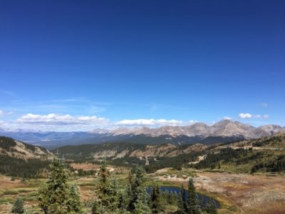
View from the summit of Cottonwood Pass looking west into Gunnison County. Photo by Jan Wondra.
Independence Pass
Oversized and overweight vehicles are strictly prohibited from using this pass at any time due to narrow and winding roads and steep inclines. These pass restrictions lie between mile post (MP) 47.2 (Aspen side) and MP 84.2 (Leadville/Twin Lakes side). This two-lane, 12,095-foot pass closes for the winter, typically on or near November 7 and almost always reopens on the Thursday before Memorial Day.
There are changing leaves, nature, and beauty as far as the eye can see. Those who enjoy hiking are encouraged to turn off on County Road 25 for the Colorado Trail trailhead to walk through a forest of fall colors.
Marshall Pass
History hounds will love this route as it follows the original railroad grade for the Denver and Rio Grande Railroad, which routed to Salt Lake City from Denver in the late 1800s. Follow Highway 285 a few miles south of Poncha Springs to County Road 200; this graded dirt road passes a historic townsite and an alpine lake before topping out just below tree line at 10,842 elevation. Keep going to find the tiny town of Sargents or head back and stop by O’Haver Lake for some fishing and a lunch spot. This area is also well known for its Fall colors and wildlife viewing.
St. Elmo or Hancock
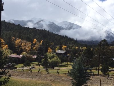
A drive west on CR 162 takes a traveler from fall to winter; with the peaks of Mt. Antero looming over Mt. Princeton Hot Springs Resort.
16 miles west of Nathrop, CO, continue up a graded dirt road, CR 162 goes straight to the St.Elmo Ghost Town. It is said that St. Elmo’s population rode the last train out of town and never came back. Leaf viewers can stop at the General Store and grab some sunflower seeds to feed to the world’s best chipmunks.
For those scared of ghosts or who don’t like chipmunks, turn left up Hancock Pass, or Forest Road 295, just a mile or two before hitting the ghost town. This alternative route will take viewers five miles up to the Alpine Tunnel trailhead, which is only accessible by mountain bike or foot.
This route needs at least an off-road vehicle to drive up Hancock. Driving Tin Cup Pass is a great addition to this route, but only if you have a Jeep, RZR, or ATV.
Vicksburg and Winfield
See colors and visit two ghost towns, Vicksburg and Winfield on the same trip. Take Highway 24 north of Buena Vista to Clear Creek Reservoir and go west on CR 390. See blankets of color on the mountainsides as you go past Vicksburg and end at Winfield after 12 miles. Clear Creek runs the length of Clear Creek Canyon, which is where miners began prospecting the tributaries to the Arkansas River in the mid-to-late 1800s.


Recent Comments