

Winter might not yet have arrived on the calendar, but the weather systems sweeping over Colorado don’t know that. As snow has started to accumulate in some high mountain areas, this past week the Colorado Avalanche Information Center (CAIC) began issuing daily weather and avalanche forecasts for the season.
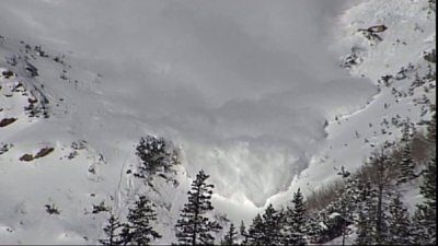
Wintertime, and the view of an avalanche on Cottonwood Pass. Ark Valley Voice File photo
Historically and annually, Colorado is the deadliest state for avalanches, killing more people than any other natural hazard in the state so this upgrade can’t come too soon.
CAIC is operating this season with a new website that does more than ever before to represent the current conditions and the risks of travel in the high country during wintertime.
Whether you’re above the tree line, tackling trails in the lower forest zones, or driving avalanche-prone roads such as U.S. 50 over Monarch Pass, or Interstate 70, this guide can help you understand the conditions you’ll face..
“Colorado has a lot of people that are living and working and visiting and recreating and traveling through the mountains. Our state, if you look at where people live and where the roads run, it doesn’t just go around the mountains, it goes right through the mountains,” said CAIC Director Ethan Greene, speaking this past weekend to Vail Daily.
“With that, avalanches in the winter time became a pretty important element for people; they really affect a lot of what people do, whether it’s the movement of services along the state transportation system, safety of infrastructure, and in some cases, occupied structures and certainly, recreation.”
The site improvements include a constantly-updated map of the current avalanche danger in the state, and travel advice as you scroll across the map. The dynamic forecast zones now show avalanche forecasts issued for areas with similar conditions. Forecasts will now be done in the afternoon and avalanche forecasts issued for the following two days will help you plan your next tour.
The site lets users customize the home page; it is set up to allow bookmarking of forecast zones, so people planning trips (whether on the road or backcountry) can assess the risks. It also provides education; offering information about how to read the “danger scale”, free awareness training, and how to read the trail signage for high-risk areas.
Today’s forecast is available here: https://avalanche.state.co.us/


Recent Comments