

Following the Jan. 31 special meeting in which the Chaffee County Board of County Commissioners (BoCC) formally approved a new election precinct map for Chaffee County, the first map of the county’s newly-redrawn voting precincts has been released. The map adjustments are being made based on the population shifts indicated by the 2020 Census. Changes also had to be made because the final legislative maps divided Chaffee into not one, but two state congressional districts: District 60 and District 13.
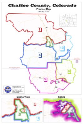 This is a first look at the map, which redraws the boundaries of the county’s voting areas, increasing the number of precincts from nine to 11. This first boundary map is what is attached to this news story.
Chaffee Clerk and Recorder Lori Mitchell cautions that Colorado provides for a 10-day window after the new maps are approved to get all the addresses in the voter registration database updated.
“This includes not only the new precincts but the databases for Congressional Districts; both the State Senate and the State House. Since we are within the 10-day window, that work is still going on,” said Mitchell.
“We are in the process of that now,” she added. “So the voters may not see the change in their own address for another couple of days.”
To see an enlarged map visit https://chaffeeclerk.colorado.gov/sites/chaffeeclerk/files/Voting-Precincts.pdf


Recent Comments