

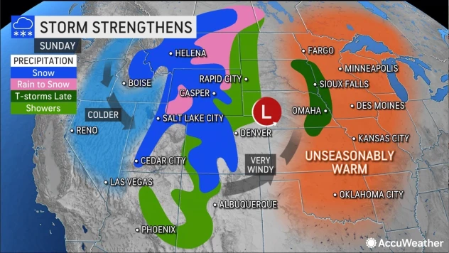

Don’t look now, but the first big storm of the season appears to be headed our direction, driving down from the north bringing blizzard conditions from the Rocky Mountains into the plains and Midwest. The arrival time is expected to this coming Sunday into Monday.
Similar to the infamous September, 1942 storm that caught hunters unawares and unprepared in the Upper Midwest, this one is preceded by a temperature rise. According to AccuWeather Global Weather Center above-average temperatures, with a potential rise of 50-70 degrees Fahrenheit, is forecast to occur over a matter of a few days, before a walloping change.
This substantial flip-flop in the weather pattern will allow a major storm to unfold smack dab in the middle of the United States this weekend and persist into early next week. The storm’s variety of adverse weather conditions could lead to a multitude of travel problems and could pose some risk to lives and property from the Rockies to the Great Plains, AccuWeather meteorologists warn.
Plains residents are being warned to expect everything from strong, dry winds to severe thunderstorms capable of producing heavy rain, hail and even tornadoes that may erupt in the southeastern zone of the developing storm where warmer air will be in place. However, on the storm’s northwestern flank (that’s us folks) the combination of plunging temperatures, heavy snow, and gusty winds may produce localized blizzard conditions in both the mountains and on the plains.
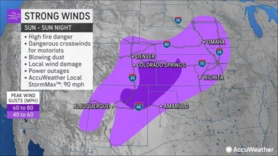 “The warmup will be accompanied by gusty south-to-southwest winds that will raise the risk of wildfire ignition and rapid spread,” AccuWeather Senior Meteorologist Brett Anderson said. “The winds can also kick up dust from the deserts and blow it hundreds of miles to the Great Plains.”
The strongest winds, which are already apparent in the Central Colorado Rockies this morning, are developing as colder air from the Northwest begins to catch up with the warmth from the Southwest states. By Sunday and Sunday night it moves into portions of the central and southern Plains.
This certainly isn’t the earliest winter storm to hit; in the past few years there has been more than one major October snowstorm in the Rockies. Ski resorts such as Monarch Mountain which does not make snow, count on them to make their openings before the Christmas holidays.
There have been other infamous September storms. From September 24 through 26, 1942, an early season winter storm moved through the Northern Plains, Upper Mississippi River Valley, and Great Lakes, dropping measurable snow as it went. In many places across Minnesota, Iowa, Wisconsin, and northern Illinois, this was their earliest measurable snow on record. Duck hunters were out on marshes and blinds, sleet and ice disrupted the wire service and power and people froze to death out in the open. Winter clothing wasn’t as advanced as it was today, and neither was weather forecasting.
Editor’s Note: This forecast and the images in this story are from Accuweather News Forecasting.


Recent Comments