

Water levels in conjunction with FIBArk (First in Boating on the Arkansas) are always a subject of intense interest, and this year is no exception. After an extended winter and cool spring, the Arkansas Valley is finally seeing some warmer temperatures. As a result, the Arkansas River and its tributaries are swelling with historic snowmelt runoff.
According to the United States Geological Survey (USGS) station near Nathrop, the Arkansas River was flowing Tuesday at 3,460 Cubic Feet per Second (cfs). Projections are that by race day at the end of the week, levels could be substantially higher. Only eight days ago on June 3, the USGS measured the Arkansas’ flow at just over 1,000 cfs.
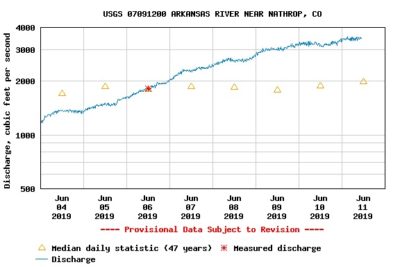
The USGS station near Nathrop measures current flow rates. The yellow triangles represent the 47-year median flow rates for June 4-11.
The average flow for this time frame, measured by the USGS over the last 47 years, was 2,010 cfs. The maximum in Chaffee County, measured in 1980, was 3,980 cfs.
Earlier this week, Fremont County Search & Rescue said they projected water flow to be close to 5,000 cfs by mid-week. They reported that the record high for the Parkdale meter in Cañon City was 5,800 cfs in 1985, and the recorded low was 467 cfs in 2012.
Though early June is typically the high water peak for the Arkansas Valley, the situation this year is anything but normal.
Phil Graham, director of Chaffee County’s Office of Emergency Management (OEM) and officials throughout the county continue to monitor rising water levels but haven’t yet projected the levels Fremont County says it may see.
“Buena Vista Fire Department is monitoring Cottonwood Creek daily,” said Graham. “So far, the water has come up but hasn’t breached any of the banks and we haven’t had any debris issues. Our biggest concern is the debris coming down and blocking the flow.”
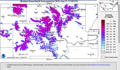
Snow depth totals surrounding the Arkansas Valley as of June 11, 2019. (Courtesy of the National Oceanic and Atmospheric Administration (NOAA)
“Historically, the week of FIBArk seems to be the real big start to our runoff season,” explained Graham. “We’ve certainly seen it. We have definitely started to see runoff. This year, there’s so much snow pack up there, our heavy runs could last a couple extra of weeks. We’re not out of the woods yet.”
The Arkansas and major feeding streams – like Cottonwood Creek and Chalk Creek– have heavy flows and the potential for flooding activity remains.
“So far we’re doing pretty good,” said Graham, “but people still need to be vigilant.”
Though potential emergency situations remain in check, high water on the Arkansas has implications for others in the valley. For rafting outfitters like The Adventure Company and Wilderness Aware Rafting, significant river flow is critical to providing quality rafting trips. However this year, the flows on the Arkansas are proving to be a challenge.
“We start seeing the big change in river flows when the overnight temperatures at the bottom of the snowpack no longer dip below freezing (two weeks ago, this was around 10,500 feet [elevation]),” said The Adventure Company’s owner, Mark Hammer.
In other words, as Graham suggested, this initial swelling of the Arkansas might not be all of what’s coming.
“This still is not the big thrust,” explained Hammer. “This is just [the] bottom of the snowpack. It’s still below freezing closer to 11,500 or 12,000 feet. “Typically, when you get your rush to your peak it’s above freezing way up high (in elevation). This is extremely unusual to be here, this far into June, and still be below freezing up high.”
Hammer pointed out that 3,200 cfs is the average peak flow for Brown’s Canyon. Typically, says Hammer, the year’s peak flow falls somewhere between June 7 and June 10.
“This — what we’ve seen so far in river flows — is just a drop in the bucket,” said Hammer said. “We’re not close to our peak yet, there’s still a ton of snow up there. This is so not average. This is unbelievable. This is a one in 30-year event.”
The Arkansas River has three sections of rapids with flow cutoffs. According to Hammer, the river flow currently exceeds all three cutoff thresholds.
“At this point, Pines Creek, The Numbers and Royal Gorge are all closed,” said Hammer. “[The other rapids] don’t have a high-water cutoff point, but that doesn’t mean everything is good to go.”
Hammer pointed out that Stone Bridge is impassable when the river flow hits 4,000 cfs, and rafting trips can’t run the Silver Bullet rapid at 4,300 cfs. Stone Bridge is located just south of Brown’s Canyon and the Silver Bullet is just south of Buena Vista.
At 5,000 cfs, the House Rock Rapid is difficult to navigate. At 6,000 cfs, “it’s a no-go”, said Hammer.
Hammer predicts his trips will likely have to put in at Johnson Village or Fisherman’s Bridge. When the water becomes too high to pass beneath Stone Bridge, trips will have to exit the river and re-launch on the south side of Stone Bridge.
“This creates a giant backup on the river,” said Hammer. “[Outfitters] are all aware and we are going to work together. We make all the adjustments for safety. Outfitters all work together for safety. Having [a] backup [plan] is always a good option.”
Joe Greiner, who owns Wilderness Aware Rafting, echoes Hammer’s assertions on safety and preparedness.
“We have internal guidelines for cutoffs and for minimum ages,” said Greiner. “As the river increases, we move people to more appropriate sections. Except for young children, we can find a trip suitable for most people.”
With FIBArk slated to begin this week, high water could put a damper on the festival.
“Those hydraulics, where they have kayak competitions, they work best at certain flows; certain moves are best at certain flows,” explained Hammer.
Though it’s difficult to know for sure, Hammer suspects the high water may impede FIBArk’s usual activities.
“High water washes out those hydraulics a bit. All the amateur stuff and the Hooligan Race, stuff like that may be canceled, but they will still have great pro competitions.”


Recent Comments