

With June breaking all global heat records and within the next 24 hours, July on track to go on record as the hottest month ever recorded on the planet (at least while humans have been keeping records), climate change is becoming something that no one, regardless of altitude, can ignore. While Colorado has been one of the few states to maintain some small areas of “green – cooler” on the weather maps during the latest heat blasts, the changes going on at all altitudes appear real, and they are intensifying.
“If this July turns out to be the warmest July (it has a good shot at it), it will be the warmest month we have measured on Earth!” tweeted Michael Mann, a climate scientist at Pennsylvania State University.
This summer the U.S. has seen heatwave after heatwave sweeping the Midwest and East Coast. This after a winter that gave the Rockies record snowfall, and the Great Plains seemingly never-ending flooding, the result of the wettest 12-month stretch on record.
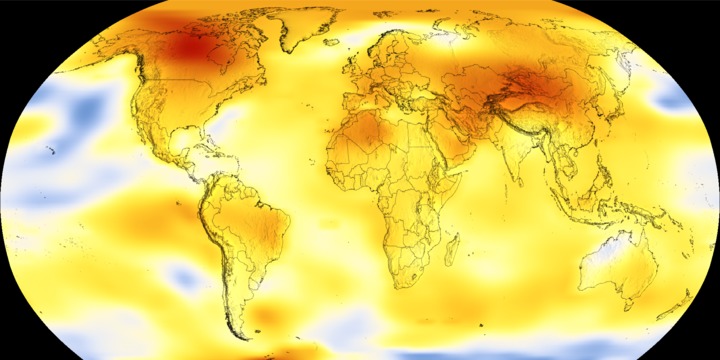
Europe has been baking all summer, with countries such as France, Italy, Germany and Spain recording temperatures exceeding 110 degrees F breaking centuries-old records. The previous June record of 0.82C above the average was set in 2016. According to a report released this week by the National Aeronautics and Space Administration, the global average temperature was 0.93C above the June norm, based on a 1951-to-1980 baseline
The planet’s heat map as it stood in 1884, with blue (cool) the prominent color. (Visual courtesy of NASA’s Global Climate Change)
Temperatures have soared in the Arctic, causing not just melting ice and glaciers, but thawing peat moss to later catch fire. The Laplanders in northern Sweden, Norway and Finland, are fighting forest fires. The severe drought in India has drained the water supplies for towns of 9 million residents. All the while, massive flooding in China and Japan has delivered five years worth of rain in a single event. The extended heat, the lack of rain, the expanding creep of desert areas, the continued movement of species (both plant and animal) upward in elevation, all indicate that this is not climate as usual.
While there are still those few who deny that anything is going on with the earth’s heat regulation, even non-scientists are cataloging observable events. In fact, according to data from NASA, nine of the 10 warmest years on record have occurred since 2000, a trend that scientists have tied mainly to human emissions of greenhouse gases.
Scientists say the concentration of carbon dioxide in Earth’s atmosphere has climbed to a level last seen more than 3 million years ago — before humans even appeared on the planet. Last weekend, sensors at the Mauna Loa Observatory in Hawaii indicated that concentrations of the greenhouse gas (a by-product of burning fossil fuels), reached 415 parts per million (ppm). Translated, this means that for every 1 million molecules of gas in the atmosphere, 415 were of carbon dioxide.
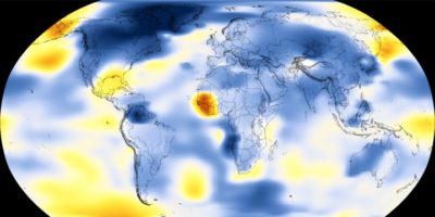
Visit this NASA site to see a global climate change map.
While climate impacts are complex, scientists say they think there is a common trigger for the “weird weather.” It’s a profound change in the jet stream, the ribbon of fast-moving air that flows west to east over the northern hemisphere, driving the earth’s weather systems.
Clashing weather systems power this jet stream with cooler polar region air, meeting warmer air moving up from the southern equator. It moves in a circle, sliding north or south over Canada and the U.S., over southern Europe and Asia, and up over Siberia, causing what weather forecasters call troughs and ridges of weather in a seasonal pattern. We know these as cold snaps (when polar air moves out of the Arctic during winter months). Or summer storm paths (as when air from the south bulges up over the U.S. causing summer heatwaves, or the recent heat blast on Europe from the Sahara Desert).
Seasonal shifts are one thing. What is happening now, according to scientists, is something else. “The winds are actually slowing down,” said co-founder and Director of Meteorology for Weather Underground, Jeff Masters, of San Francisco. “[the jet stream] is a very wiggly snake right now.”
The NASA website explains it this way: “Climate change is causing big wavy patterns to form in the jet stream, a ribbon of normally fast-moving air in the atmosphere over the Northern Hemisphere.” In other words, the jet stream is becoming more gnarled, and the normal, significant wavy patterns have not just slowed to a crawl; in some areas, they have completely stalled.
While this might not sound like much, climate experts say this is a big deal. A sluggish jet stream that slows or just stops over an area as high pressure or low-pressure can intensify weather events. Take the extreme rainy period five years ago when a system stalled over Colorado’s northern Front Range foothills, causing epic flooding. A stall can extend what used to be days-long heatwaves into weeks-long heatwaves with devastating impact – including a swiftly-rising, nearly constant fire danger.
Scientists say that since the year 2000, unusual but predictable jet stream behavior has been recorded about every three to five years; 2003, 2006, 2010, 2015 and 2018. But this is the first year ever when it has returned two years in a row.
“It doesn’t look like an anomaly anymore when you get these recurrences over and over,” said The Earth Institute at Columbia University, Climate Scientist Kai Kornhuber. “I wouldn’t have expected this situation to return so quickly after the extreme summer last year. It gives me the chills to see this evolving in real-time again. It’s a really worrying development.”
According to Kornhuber and other scientists, this jet stream wiggle is actually a stalled wave pattern and, according to their data, responsible for an estimated 50 percent increase this century in extreme weather events. As the jet stream stalls, the temperature differences between the equator and the poles is slowly being erased.
For those who like to claim that climate change is not occurring because they haven’t seen anything different in their local area, scientists say ”give it time.”
“The earth is not warming everywhere at the same speed,” said Kornhuber. “The Arctic and areas of higher altitudes are warming twice as fast in the summer than other regions, which is what is producing favorable conditions for a very wavy jet stream.
“Extreme weather events are becoming the new normal,” said University of Wisconsin-Madison’s, Nelson Institute for Climate Research Senior Scientist Steve Vavrus. “…and they last longer than they have in the past.”
He points out that the severity of hurricanes and winter storm events is continuing to intensify. From a scientific standpoint, says Vavrus, the way to lessen the danger is to reduce the world’s carbon emissions. Slow down global warming and return the jet stream to its more typical speed and pattern.


Recent Comments