

Rocky Mountain Incident Commander Mark Giacoletto reports that crews made excellent progress throughout the Decker Fire Saturday. Firefighters are combating the fire in four divisions R, T, W and X, divided into two branches – a northern branch and the southern branch. With calmer winds on Sunday, more aircraft action will be taking place.
The incident command has now completed an interactive map, allowing residents to put in their address to see how far away the fire is from their residence. It also provides distance, as well as areas closed to hunters, and road closures. They stress that this is not a live map, and the fire perimeter it references will be updated once per day.
The interactive map available for the Decker Fire can be accessed at www.arcg.is/1zPGWH.

The fire now stands at 6,155 acres, with 806 personnel on the ground in the fire fighting command. While low humidity conditions continue, with overnight temperatures 45-55 F, winds were not as bad as predicted Saturday evening and should calm as Sunday goes on. A ridge of high pressure is expected to build into the fire area Monday, bringing with it a dry and unstable environment.
On the north and northeast side, the firefighters were able to improve the fire line. Teams were successful in wrapping it around the bottom of the arm, all the way to the Columbine Trail. On the southeast side, crews will be scouting for fireline options on Sunday for staging bulldozers.
Firefighters on the south side used bulldozers to start improving the Bureau of Land Management (BLM) roads 982 and 5350, which it will use as a southern fire line. Crews kept growing lines on the west and monitoring fire behavior. Some aircraft were able to fly earlier yesterday, but high winds grounded others.
On Sunday, firefighters on the northwest side will improve the bulldozer line south of Boot Hill. They will look for options to improve the Rainbow Trail between the fire’s edge and the bulldozer line that connects to CR 124, west of the fire.
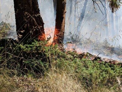
Saturday afternoon winds picked up over the Decker Fire, but not as bad as had been feared, allowing firefighters to continue building fire lines. (Photo by Jan Wondra)
Crews will work to improve the Columbine Trail from Bear Creek west toward Rainbow. Then follow and improve the Rainbow Trail heading south, allowing them to keep “boxing off” sections of the fire area with an indirect fire line. Crews on the northeast side will also be scouting further east on BLM land, looking for options to improve small roads that travel south from U.S. 50.
Firefighters will keep scouting for indirect fireline options between the fire and the community of Howard on the southeast side. Bulldozers are already staged in this area, and they may be working today from the intersection of Fremont CR4/4A, moving west toward the fire.
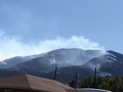
The Decker Fire in the Sangre de Cristo Wilderness areas. (Photo courtesy Judi Perez)
Infrared maps are showing a spot fire in this area, just to the northeast of the old Oxcart burn scar. Incident command cautions Howard residents that they may see smoke today, and they should expect to see helicopters working to cool this spot.
Chaffee County Sheriff John Spezze has confirmed that in addition to one residence lost in Fremont County, one structure has been lost in Chaffee County. “It’s a hunting cabin high up on private land surrounded by forest on Methodist Mountain,” said Spezze. “The owner is in Texas, and there was nothing that could be done to save it.”
Incident command cautions residents that they are likely to see more smoke on Monday, Oct. 7. If conditions allow, fire teams might be doing back-firing and aerial ignitions on the northeast side, to remove fuels and create “black” between the fire and the values at risk. When conditions are right, these types of firing operations allow managers to work the fire on their own terms, at the right time and in the right place. Removing fuel from the fire front effectively slows the spread and places “black” between the fire and the values at risk.
Hunters should be aware that there are also new BLM closures and fire restrictions (see companion story on the BLM).
Decker Fire Rocky Mountain Incident Command Center:
(719) 626-1095Hours of operation: 7:30 a.m.–9:30 p.m.
Website: www.inciweb.nwcg.gov/incident/6592/
Facebook: www.facebook.com/DeckerFire2019/
Email: 2019.Decker@firenet.gov
There are multiple road closures around the Decker Fire area in Chaffee, Fremont and Saguache counties. For personal safety and firefighter safety, officials are asking the public to respect posted closures.
For San Isabel Forest closures: www.tinyurl.com/SanIsabelClosures
For Rio Grande Forest closures: www.tinyurl.com/RioGrandeClosures
For BLM closures: www.tinyurl.com/BLMCLosure
For evacuation information, please contact:
The Chaffee County Sheriff’s Office: 719-539-2596, or
Fremont County Emergency Management:719-276-7416, 719-276-7418, or go to the Chaffee County Sheriff or Fremont County Sheriff Facebook pages and websites.
The Decker Fire is divided into two Branches:
Branch I (on the northeast side by Salida) and Branch II (on the southwest side the San Luis Valley). Then subdivided into five divisions.
Branch I - Salida
• Division T (northeast side by Wellsville)
• Division R (north side by Salida)
• Division W (southeast side by Howard)
• Division A (west side by Poncha Pass)
• Division X (south side by Alder)


Recent Comments