

We took off on a calm, clear morning, heading east out of Harriet Alexander Field at Salida Airport and down the drop of the Arkansas River toward Cañon City. Below us stretched the rugged, unspoiled landscape of buttes and gorges, tabletop mountains and a rushing river headed down the canyon of the Arkansas. Our objective: to overfly some of the 278,000 acres proposed by the Bureau of Land Management (BLM) for a rollback of protection from development and mineral exploration. With the BLM public comment period deadline of Sept. 20 looming, citizens have only a few more days to make their voices heard.

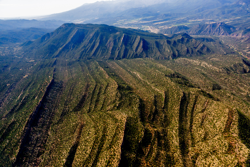
The Arkansas Hills to the east of Salida and Tenderfoot Mountain could become a target of development if the BLM “preferred” plan D is selected. (Photos courtesy EcoFlight)
“These public lands belong to all of us,” said Wild Connections Conservation Director John Sztukowski above the roar of the plane. “The BLM manages them on our behalf, so it’s important that people make their voices known in this process.
“The BLM isn’t listening to the input of the people. See how few roads there are through this wilderness? Consider what we value — if the BLM follows through on this, there could be mining exploration right in the hills behind Tenderfoot Mountain.”
The BLM Royal Gorge Office manages a total of 658,200 acres of wilderness, as well as more than $33 million in mineral estate acres in central and eastern Colorado. BLM National is reviewing its Resource Management Plan, a process that began in 2015. These plans determine whether a wilderness area is opened for oil and gas exploration or mining, managed for hiking, hunting, fishing, or as set-aside areas for wildlife habitat.
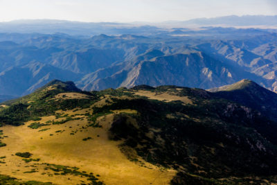
A view of Table Mountain looking southwest toward the Arkansas River Valley. The area is home to 17 kinds of native grasses.
Recently the process has sped up, as the Trump administration has called for more public lands to be open for energy and mineral exploration under its “energy first” policy. In fact, as it is being executed, that policy would open as much as 98 percent of BLM-managed land surface to development.
The journalists crammed into the EcoFlight, piloted by Bruce Gordon, were there to see for themselves, the lands that might become available for what Sztukowski calls “exploitation.”
It appears the preferred BLM proposal (known as option D) would carve out for protection only 47,600 acres of the existing preferred protection area of 278,000 acres lying east of Salida. This represents more than an 82 percent reduction in the protected wilderness between Salida and Cañon City.
Key to that action, says Sztukowski, would be the removal of overlapping map protection areas; where an area could be designated as protected hunting, or hiking, but perhaps not as a protected wildlife habitat.
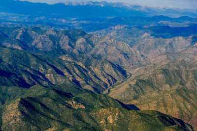
View over the Arkansas River toward the Sangre de Cristo Wilderness.
“The BLM is proposing to strip out overlapping designations,” said Sztukowski. “The result could be terrible. Just consider the western end of Table Mountain, where 17 different types of native grasses have been identified. This is a wilderness ecosystem that, once gone, will never be restored.”
Gordon, an Ecoflight volunteer who had flown over that morning from Aspen, pointed out key features of the landscape: Bighorn Sheep Canyon, the wilderness areas of Badger Creek and Texas Creek, Echo Canyon, and the rugged edges of Table Mountain.
Here and there we could see the faint image of a road – a few private off-grid homes. But primarily the view was of unspoiled wilderness. What we were viewing was a corridor through the central mountains, including 12 threatened BLM wild areas that would become disconnected and open for development, should the BLM’s preferred option be selected.
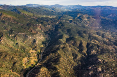
Looking east toward Arkansas Mountain in Badger Creek south to Coledale and Cotopaxi.
When the BLM released its preliminary alternatives in 2017, the categories of “Lands with Wilderness Characteristics” and “Areas of Critical Environmental Concern” got the most comments, indicating a high public preference for protection. This year, the BLM released its ‘preferred alternative” (D) which proposes to manage only 1,300 acres of Lands with Wilderness Characteristics – exactly zero acres of priority areas between Salida and Cañon City.
“Here in Colorado, we recognize the importance of keeping wild lands wild, not just as a scenic backdrop, but because an intact natural ecosystem is critical to the survival of many species and to our health and well-being,” wrote Wild Connections President Jim Lockhart in a document outlining concerns over the BLM’s push toward removing protections.
His organization has pointed out that the BLM has demonstrated “a pattern of ignoring local input, zeroing out conservation while prioritizing development … as it is being pursed, the BLM national office has ignored years of public process – including comments from people…who support protection of the environment – as well as the conclusions of its own local office.”

The media flight included, left to right, John Sztukowski, Jan Wondra, Ron Sering, DJ DeJong and the EcoFlight photographer.
Citizens wishing to make their voices heard can submit comments to John Smeins of the BLM Royal Gorge Field Office at 3028 E. Main St., in Cañon City, CO 81212. Comments can also be made online at www.go.usa.gov/xQcZt.
Sztukowski says that citizens wishing to comment should read the directions carefully, and highlight personal experiences in the use and enjoyment of the wilderness areas.
He suggested that given the Sept. 20 cutoff, it would be better for comments to be made online. Local residents can also go to www.WildConnections.org for more information about the kinds of information to include in their comments.
“Show how your community is affected and which specific wilderness areas you wish protected,” said Sztukowski. “This is personal and local.”
Lead photo: South Badger Creek.
Wilderness areas threatened with BLM protection removal:
- Bear Mountain
- Echo Canyon
- Table Mountain
- Badger Creek (north and south) Bighorn Sheep canyon
- Eightmile Mountain
- Red Canyon
- Cooper Mountain
- Cucharas Canyon
- North of Cotopaxi
- Upper Red Canyon
- Beaver creek


Most of us see these wild lands in the Arkansas Canyons from Highway 50. This view from above highlights the immense expanse of canyons, high mesa tops and waterways. From high in the air it is obvious that we have a treasure that should not be squandered today at the expense of future generations of people, plants and animals. The comment period is closed, but thank you to everyone who let the BLM know that these lands are everyone’s future.
Do not open public lands for energy and mineral exploration in Colorado
Preserve wilderness area — we are to take care of the planet not ravage it !