

Wishes for a white Christmas after a brown and dry fall may just come true for Chaffee County and the Central Colorado Rockies. A winter storm is moving in from the northwest, with predictions of three feet of snow or more along the I-70 corridor and hazardous driving conditions. That winter storm warning begins at 11:00 a.m. today and is the first of five storms that appear to be be poised to drop winter white across the Colorado Rockies.
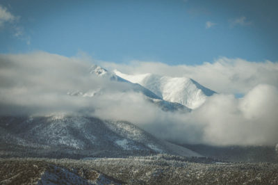
Collegiate Peaks Southern Rocky Mountains photo credit- Sandy Hobbs
Here in Chaffee County, predictions are more modest than further north, but still, hopes are high for major snow totals on our beloved Monarch Mountain Ski Resort, which still operates only with natural snow and does not use snow-making equipment.
Improvement in the snowpack, particularly on the state’s high peaks is critical to the state, as drought conditions exist across major portions of Colorado.
The National Weather Service has issued the following seven-day forecast for the central section of rural Chaffee County in Nathrop, which includes the area around Mt. Princeton Hot Springs Resort:
Today
A chance of snow showers between 10:00 a.m. and 12:00 noon, then rain and snow showers likely. Mostly sunny, with a high near 46. Breezy, with a west wind 15 to 20 mph, with gusts as high as 30 mph. Chance of precipitation is 60 percent. Total daytime snow accumulation of less than a half-inch possible.
Tonight
Rain and snow showers likely before 7:00 p.m., then snow showers. Low around 32. Breezy, with a southwest wind 20 to 25 mph, with gusts as high as 40 mph. Chance of precipitation is 100 percent. New snow accumulation of 1 to 3 inches possible.
Friday
Snow. High near 41. Breezy, with a west southwest wind 15 to 25 mph, with gusts as high as 40 mph. Chance of precipitation is 90 percent. New snow accumulation of 1 to 2 inches possible.
Friday Night
Snow likely, mainly before 11:00 p.m.. Mostly cloudy, with a low around 23. Breezy, with a west southwest wind 20 to 25 mph, with gusts as high as 40 mph. Chance of precipitation is 60 percent. New snow accumulation of less than one inch possible.
Christmas Day
Mostly sunny, with a high near 38. Breezy, with a west southwest wind around 20 mph, with gusts as high as 35 mph.
Saturday Night
A 30 percent chance of snow after 11:00 p.m. Partly cloudy, with a low around 21. Southwest wind around 15 mph.
Sunday
A 50 percent chance of snow. Patchy blowing snow after 11:00 a.m. Partly sunny, with a high near 33. Windy, with a west southwest wind 25 to 30 mph, with gusts as high as 45 mph.
Sunday Night
Patchy blowing snow before 11:00 p.m. Partly cloudy, with a low around 12. Windy, with a west southwest wind 20 to 30 mph.
Monday
A 40 percent chance of snow, mainly after 11:00 a.m. Patchy blowing snow between 11:00 a.m. and 4:00 p.m. Partly sunny, with a high near 30. Breezy, with a southwest wind 15 to 20 mph, with gusts as high as 30 mph.
Monday Night
A 50 percent chance of snow. Patchy blowing snow. Mostly cloudy, with a low around 16. Breezy, with a west southwest wind 20 to 25 mph, with gusts as high as 35 mph.
Tuesday
A chance of snow. Patchy blowing snow. Mostly sunny, with a high near 28. Breezy, with a west southwest wind around 20 mph, with gusts as high as 35 mph.
Tuesday Night
A chance of snow. Partly cloudy, with a low around 12. Breezy, with a west southwest wind 15 to 20 mph, with gusts as high as 30 mph.
Wednesday
A chance of snow. Partly sunny, with a high near 30. Southwest wind around 15 mph.


Recent Comments