
The Salida City Council (SCC) and the Planning Commission (PC) held a joint work session on July 31 to hear presentations from Studio Seed, the consulting group hired by the city to work on plans for the South Ark Neighborhood. Afterwards Read McCulloch, of the Chaffee Housing Trust, advocated ground leases as a land-use ownership model for the Vandaveer Ranch property where the South Ark Neighborhood is located.
![]() Community Development Director Bill Almquist introduced Studio Seed consultants Cheney Bostic and Andy Rutz, who presented the latest site plan variations for South Ark Neighborhood. First, they revisited the project timeline, stating that they were now in Phase 3, which included wetlands mapping; more feedback sessions with stakeholders, including housing advocates and environmental and river groups; and interviews with builders and developers, culminating in the two draft site plans (1A, 1B) presented.
Community Development Director Bill Almquist introduced Studio Seed consultants Cheney Bostic and Andy Rutz, who presented the latest site plan variations for South Ark Neighborhood. First, they revisited the project timeline, stating that they were now in Phase 3, which included wetlands mapping; more feedback sessions with stakeholders, including housing advocates and environmental and river groups; and interviews with builders and developers, culminating in the two draft site plans (1A, 1B) presented.
Bostic went on to outline Phase 4: “After an August Open House [to display the draft plans to the public], we will develop the final plan in accordance with the master [comprehensive] plan and then deliver it in the fall.”
Plans 1A/1B, show balanced uses and subtle differences

South Ark Neighborhood project timeline. Image courtesy of the City of Salida
The major difference between Plan 1A and Plan 1B is the placement of the future recreation center and the Neighborhood’s park, which would result in slightly different housing densities.
Plan 1A places the rec center closer to the designated wetlands and open space. Plan 1B places the rec center closer to the housing developments.
Because that would be space lost to housing, Bostic pointed out that higher-density housing would need to go in the space by the rec center.

Plan1 A and Plan 1B, South Ark Neighborhood with key differences outlined in red circles. Image courtesy of City of Salida
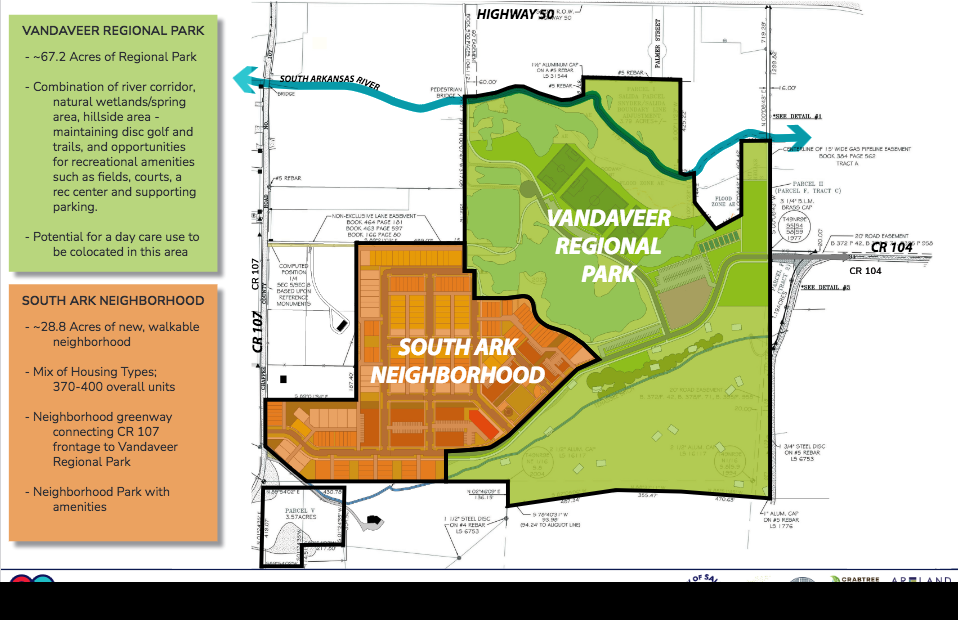
Both plans split the former Vandaveer property into two parts: the South Ark Neighborhood, for housing, and the Vandaveer Regional Park, which itself consists of four sub-areas.
Bostic listed the four sub-areas as the River Corridor, a Recreation area with soccer fields and tennis/pickleball courts, Wetlands (which after mapping proved to be more extensive than previously thought) and the Hillside area where the disc golf course is currently located.
“There’s interest in having a dog park,” Bostic said, “which could be located in the cottonwoods area by the hillside.”
Rutz went over the housing types that would be featured in the South Ark Neighborhood as a combination of apartments, townhouses and rowhouses, duplexes, and single-family houses. He also laid out the four development phases. The first phase would bring water and sewer infrastructure from Highway 50 to the site, and would be the most expensive, according to Salida Community Development Director Bill Almquist.

South Ark Neighborhood Option 1B preliminary massing. City of Salida and Studio Seed image
The major question of the evening, said Bostic, was: “Do these [plans] look good or should we go back to the drawing board?”
During the discussion, council member Alisa Pappenfort asked Almquist about Colorado Mountain College. “CMC is not particularly interested in a campus on the site, they want workforce/student housing instead,” Almquist replied: “There may be interest [in a campus] down the line, but not right now.”
“I’m impressed by the wetlands plan, plus 400 units [of housing in Plan B],” said council member Dominique Naccarato. “I like the rec center next to the neighborhood – there’s less parking on the green space.”
Mayor Pro-Tem Justin Critelli asked about the possibility of baseball fields on the site.
“It’s not in this plan, but it’s not impossible, especially if we are talking Little League and T-Ball,” said Parks and Recreation Director Diesel Post, who joined the meeting remotely. “I’ve been looking at Marvin Park and looking around for other sites. I like multi-use fields out there [in Vandaveer] rather than baseball fields. I like Option 1B, with the community park next to the rec center. We will have to figure something else out for baseball fields.”
“We were not aware of the extent of the wetlands out there,*” added Almquist. “Not to say that they are undevelopable, but mitigation would be a time-consuming process. The Army Corps of Engineers is saying that their first choice [would be] wetlands credits, which makes wetlands available elsewhere, but they would cost millions of dollars.”
“It’s incredible the amount of wetlands out there,” said Post: “These wetlands are valuable…and need to be preserved.”
After further discussion about traffic flows between the development and Highway 50, infrastructure costs and financing, and housing types such as assisted living (which Almquist said would not be ideal for the location) and co-housing or “micro-housing”, Mayor Dan Shore thanked the consultants and asked council members, “Do we want to put these two options before the public?”
“I would like to see that wetlands stay protected,” Pappenfort replied: “By presenting both options to people we are saying we think they are both valid – I think we should just go with the one we like (Option 1B).”
“I think we should get input from the public [on the choice],” said Critelli.
“I’m not sure we need any more input from the public [on the choice] – we’ve had a lot already,” said council member Jane Templeton.
Deed Restrictions compared with Ground Leases as planning tools
Read McCulloch of the Chaffee Housing Trust then talked about ground leases as a way for the city to retain control of the land, which could increase the chances for housing affordability. “That land (the Vandaveer Ranch) was paid for with taxpayer dollars,” McCulloch argued: “The city has to act as stewards of the land. A ground lease retains control of the land while allowing for private development. It also forestalls foreclosure [on any buildings.] Deed restrictions are lost in foreclosure – a ground lease allows you to keep the land and doesn’t get resold at market rates.
Developers can still develop [the South Ark Neighborhood] and get funding, but keep in mind that you don’t have to sell land to pay for infrastructure. I sincerely hope you consider using ground leases.”
“Who holds this ground lease?” asked Critelli.
“Whoever controls the land,” McCulloch replied. “The city could issue it – or the city could remand it to the [Chaffee] Housing Authority.”
In answer to more questions from Council, McCulloch added that deed restrictions can also be put on buildings on a ground lease, and that selling development rights, rather than selling the land outright, could help pay for infrastructure. “You can always sell the land later if you want to – but it has to be written into the contract.” He concluded by advocating ground leases as a way of “retaining public control of a public asset.”
“I think “legacy” sitting up here [on the Council dais],” said Shore: “I would love to think that future councils would look back and say we had made a forward-thinking decision – I would like to think we could retain the land.”
“Our deed restrictions are in perpetuity,” said Almquist: “Phasing does not preclude selling [land] – it all comes down to whatever the agreements are. [Phasing] allows for different types of modeling – it allows us to go back to plan development five to six years down the line. Ground leases will allow you to decide that you can repurpose land use as you see fit.”
Summing up, Almquist said, “I’m not sure whether we are going to present one plan or two, but it looks like we are bringing Studio Seed back for an open house in late August. If the public has input, we can take it there.”
Editor’s note: *This point about wetlands is not accurate. Ark Valley Voice Publisher/Managing Editor has reported on the Vandaveer parcel since 2016 and from the beginning when the land was under the oversight of the Salida Natural Resource Development Corporation, it was known that there was a significant wetland area around which planning would need to be done.
Featured image: South Ark Neighborhood and Vandaveer Regional Park Plan. Image courtesy of City of Salida


Recent Comments