
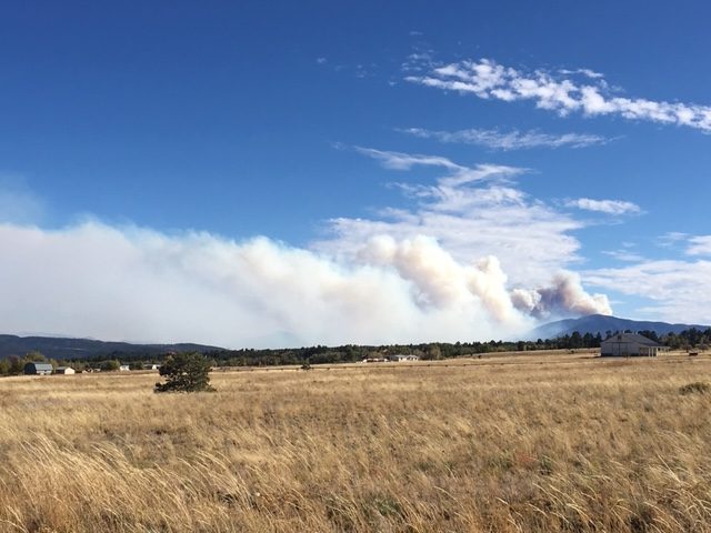

More than 160 people attended the Oct. 1 Decker Fire public information meeting in Salida, organized by the fire management team. The packed room listened intently, as the smoke cloud loomed through the windows of the Scout Hut.
“This is a combination of weather, plus fuels, plus topography said Salida Fire Management Officer and nationally qualified Fire Behavior Analyst Chris Naccarato. He explained the situation of dealing with a fire burning in wilderness terrain, as compared to a tornado or a hurricane, or a flood. “Fire is the only natural disaster that we put people in front of to try to stop it.”
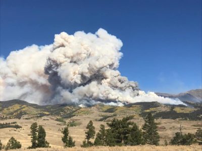
View of the Decker Fire. (Courtesy the Decker Fire Facebook page)
The fire started on Sept. 8 with a lightning strike and has grown to more than 2,200 acres on Tuesday, mostly in steep, high elevation, beetle-kill wilderness. Currently, there are more than 200 firefighters on the scene, battling the fire.
Pat Seekings, the operations section chief, updated residents on the fire’s status. He noted that yesterday there had been more fire activity on the west side of the fire, causing a lot of smoke in Salida, as it came up and over the divide. Hand crews had been working hard and were effective in putting in a line on the southwest edge of the fire. They also kept the fire from spreading to the east, down-slope of the Rainbow Trail.
On the fire’s north side, north of Methodist Mountain, much of the fire is still in high, steep, rugged terrain that is hard to access where firefighter safety is a concern, according to Seekings. Heavy winds from the west-southwest have caused spot fires on the upper end of the fire, coming over the hill. Seekings reiterated that, given the high winds, the firefighters need to be down low, where the fuel changes from the big, dense dead trees to shorter fuels, to be more effective.
Along CR 101 and Bear Creek the team has assessed and mitigated homes using plumbing, water sources and hoses. Seekings added, “The ‘structure team’ is trying to be proactive in case the fire wants to move downhill.”
Bob Morasko, CEO of Heart of the Rockies Regional Medical Center, had positive words to describe the firefighting teams and the work they are doing. He posted a Facebook video of the mitigation of his home, on Methodist Mountain www.facebook.com/bobmorasko/videos/10221344151012413.
Naccarato noted that topography and weather, drive the spread of the fire. Firefighters can only affect the part of the fuel of fighting the Decker Fire. He went on to explain that the Decker fire fuel includes grass, which transitions to brush, and, on the east side, piñon juniper. Uphill, there is an alpine forest of spruce or fir. “For the most part, the Decker Fire is burning in the spruce and fir forests. These fuels burn with low frequency, and high intensity and a large amount of beetle kill are what is mainly fueling the fire. When the fire gets to the aspens, it’s mostly slowing or stopping because aspen is moist now. These types of fires burn every 150–300 years and they reset the forest.”
Naccarato said they are hard to suppress because of the intensity of the fire. “This fire is not consuming that much ground from 400–600 acres on a big run. However, there are millions of tons of fuel going up in smoke. That is causing a large column of smoke.”
Compared to the Hayden Pass Fire, the Decker Fire is moving slowly. It has burned for 24 days and consumed approximately 2,000 acres, compared to the Hayden Pass Fire, which destroyed consumed 13,000 acres in two days.
“Firefighters don’t want to fight the fire in the heavy fuels where we have a low probability of success. What we do is look for areas of [the type of] fuel changes,” noted Nacarrato. “This gives us a higher probability of success while minimizing risk to firefighters.”
Agency administrator for the San Isabel National Forest Jim Pitts explained that there is a new level of complexity in managing the fire and additional help is needed to manage it. A new incident commander and his team will be shadowing the current team this week and will be transitioning fully on Friday.
“The strategy won’t change but the tactics on how we engage this fire [change] as needed,” said Pitts. The current team has outgrown their current incident command post and will set up camp on the Vandaveer Ranch land.
There has not been a break in the weather from rain, making it likely that this fire is a long duration event.
“This is a dangerous job, and as [Naccarato] alluded to, this is the only natural disaster we ask people to go stand in front of. When a tornado comes, everyone looks for the shelter. When a hurricane comes, everyone heads out of town. When the fire bell rings, the men and women take on that charge and go to it. It’s just going to take a little bit of time to get there.”
Pitts got choked up saying that he’s also part of this community and his family has been evacuated three different times. The last thing his wife said to him tonight was to make sure they didn’t get evacuated a fourth time.
For daily updates on the fire, go to www.facebook.com/DeckerFire2019. The meeting was recorded and is available on Facebook.
County Commissioner Greg Felt thanked Justin Yankey, the current incident commander and his team for being here for the past 12 days and their public relations process. “This has been, by far, the best public information campaign around an incident like this,” noted Felt.
The Community Wildfire Protection Plan Meetings are scheduled for Oct. 2 in Poncha Springs and Oct. 3 in Buena Vista. Residents from Fremont and Lake counties are also invited. Visit www.centralcoloradoconservancy.org/envision-accomplished for details. These meetings are not about the Decker Fire and were planned long before the fire began. Felt asked folks to come and learn about wildfire risk and help develop steps to improve the community’s readiness for severe fire.
The Decker Fire is divided into two Branches:
Branch I (on the northeast side by Salida) and Branch II (on the southwest side the San Luis Valley). Then subdivided into five divisions.
Branch I - Salida
• Division T (northeast side by Wellsville)
• Division R (north side by Salida)
• Division W (southeast side by Howard)
• Division A (west side by Poncha Pass)
• Division X (south side by Alder)


Recent Comments