


If you thought the Decker Fire seemed to be larger and more ominous yesterday, you were right. Yesterday’s critical fire weather conditions caused a significant increase in fire activity. The fire area grew by 706 acres, now covering an area of 2,207 acres. There are currently 220 firefighters on the fire lines.
Tuesday continues to be another critical fire weather day, with Red Flag wind conditions forecast to continue until 7 p.m. tonight. Firefighters say that the continued low relative humidity of 11-16 percent is drying the fuel load even more. While high wind speeds and low cloud cover tends to support both high fire activity and the growth of the fire area.
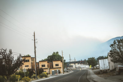
View from 7th Ave near Monarch Spur Trail of smoke moving in at approximately 6:50 p.m. on Sept. 30. (Photos by Sandy Hobbs)
For a second day, winds are out of the south and southwest, blowing the smoke north and northeast of the fire. That same high wind will generate a visible plume in the upper atmosphere moving across northeastern Colorado.
The smoke produced by fire activity Tuesday is expected to impact air quality in the Salida and Poncha Springs areas. Haze from the fire is drifting across Chaffee County toward the north. Air quality on the southern end of the county is expected to be good to moderate during the early part of the day. However, it will worsen during increasing fire activity to Unhealthy for Sensitive Groups (USG). Then move toward the unhealthy range for several hours on Tuesday afternoon and early evening.
For more about air quality access the Air Quality Guide for Particulates.
Overnight Tuesday, smoke concentrations are likely to improve to the good to moderate range. Incident command says that the long-distance transport of smoke may cause haze further northeast of the fire, in the South Park area and potentially extend across the Front Range. Wednesday, an expected wind direct shift will likely shift the impact of the smoke.

Smoke moving in along with twilight at the Longfellow Elementary School.
Incident command reports that on the northeast, the fire remained calm. Monday morning bucket work by helicopters helped to slow the spread to the northeast. However, fire activity increased significantly in a previously inactive area.
Driven by strong winds from the south, the fire burned northward from the Green Rocks area toward Simmons Peak. Not that the public would want to be anywhere near dense sections of unburnt fuel, firefighters report flames were 80 to 100 feet high, as the fire grew approximately 600 acres in that one area.
Incident command explained the smoke column appeared so large and dense due to the heavy concentration of dead and down fuel that has built up in the forest over the years. Some “spot fires” were detected on the San Isabel side near the upper Rock and Bear Creek drainages. Monday evening, a night shift was established on the fire. Two engines and a task force leader monitored behavior overnight and will continue to do so as long as needed.
Critical fire weather and high winds are expected to persist through the week. Fire conditions on Tuesday include the likelihood of heavy smoke and plumes. Helicopters flew this morning to cool spots from yesterday’s growth. And multiple lookouts are posted to spot any new developments. Crews and bulldozers on the north will scout for additional opportunities for fire lines outside of the wilderness. Structure protection crews will be present in Silver Heels and Bear Creek. Firefighters say that as the fire reaches wilderness boundary and safer terrain, they have a much stronger probability of success and can engage in more aggressive suppression efforts. Fire managers have ordered additional resources for this purpose.
The majority of the fire is burning in an inaccessible wilderness full of dead and down fuel where it is unsafe for firefighters to go. Helicopter water drops can only slow and cool the fire in this area. Portions of the wilderness may burn until fuels have been consumed or after a season-ending event such as significant and sustained snowfall. Limiting spread onto private and BLM land and ensuring firefighter and public safety remain top priorities.
Air Quality Guide for Particulates
For individuals who may be more sensitive to smoke: www.tinyurl.com/ReduceYourSmokeExposure.
Real-time smoke information is available at www.tinyurl.com/DeckerFireSmoke.
Today’s smoke forecast for Salida and Arkansas River Valley is available at www.wildlandfiresmoke.net/outlooks/CentralColorado.
Road Closures: CR101 and CR 101A on National Forest lands and the Rainbow Trail (1336 trail) south of 108 road to the Stout Lakes Trail (1403 trail) are closed. Chaffee CR101/CR 49 (Bear Creek Road) in Fremont County is closed (open to local traffic only).
Decker Fire Statistics:
Size: 2207 acres, with 5 percent containment
Total Personnel: 220
Cause: Lightning
Start Date: Sept. 8, 2019
Location: 9 miles south of Salida
______________________________________
Decker Fire Information Office
Fire Info Line: (719) 626-1095
InciWeb: www.inciweb.nwcg.gov/incident/6592/
Facebook: facebook.com/DeckerFire2019
Twitter: #DeckerFire2019
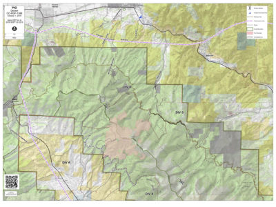
The Decker Fire is divided into two Branches:
Branch I (on the northeast side by Salida) and Branch II (on the southwest side the San Luis Valley). Then subdivided into five divisions.
Branch I - Salida
• Division T (northeast side by Wellsville)
• Division R (north side by Salida)
• Division W (southeast side by Howard)
• Division A (west side by Poncha Pass)
• Division X (south side by Alder)


Recent Comments