

The latest update on the Decker Fire indicates that winds may increase the fire behavior on Thursday, Sept. 26, after minimal fire advance on Tuesday. The active fire on Simmons Peak continued to slowly back down towards the Rainbow Trail into drainages, burning out interior pockets of dead and down timber. Winds out of the southwest, with gusts up to 39 mph will be the main factor today.
Crews are clearing the section of line near the intersection of CR 101 and the Rainbow Trail. These actions are to meet the incident’s objective of keeping the fire in the wilderness areas. On the west side, crews utilized Round Hill Trail and two-track roads to check the fire from advancing to the north.
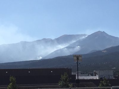
The Decker Fire burning in the Sangre de Cristo Wilderness is visible on Wednesday as a backdrop to Salida High School. (Photo by Jan Wondra)
Today, the Teton Wildland Fire Module and Juniper Valley hand crew will prepare in a fire-line to the northwest to keep the fire off private and Bureau of Land Management (BLM) property. The terrain is steep and inaccessible, with heavy fuels. According to incident command, the firefighter’s safety is of primary importance. Crews will engage directly with the fire, “where the probability of success is high and firefighter exposure is minimized.”
Fire crews scout for opportunities to use natural and existing control features. On the east side, Alpine Hotshots will monitor fire spread towards the Rainbow Trail, implementing firing operations if necessary. Pike Hotshots and Wind Cave Engine 629 will also scout options for a direct line to tie fire into southern wet drainage of Bear Creek.
Today’s weather will see mostly sunny skies, unseasonably warm temperatures, and low relative humidity. There is a chance of isolated thunderstorms after 1 p.m. which could bring erratic and gusty outflow winds and lightning to the fire area.
The fire may be visible from both the U.S. 50 and U.S. 285 corridors. The U.S. Forest Service asks that motorists not stop or call 911 to report fire behavior on the Decker Fire or to request fire information. A fire information line (below) is available for fire updates.
Evacuations and Closures: Portions of CR 101 and CR 101A on National Forest System lands and the Rainbow Trail (1336 trail) south of CR 108 to the Stout Lakes Trail (1403 trail), as well as the forest areas, have been closed to bikers, hikers and hunters. A temporary flight restriction (TFR) has been issued over the fire area to allow for aerial operations.
Today’s smoke forecast for Salida and Arkansas River Valley is available at www.wildlandfiresmoke.net/outlooks/CentralColorado.
Decker Fire Statistics:
Size: 1150 acres
Total Personnel: 127
Cause: Lightning
Start Date: Sept. 8, 2019
Location: Nine miles south of Salida
The Decker Fire is divided into two Branches:
Branch I (on the northeast side by Salida) and Branch II (on the southwest side the San Luis Valley). Then subdivided into five divisions.
Branch I - Salida
• Division T (northeast side by Wellsville)
• Division R (north side by Salida)
• Division W (southeast side by Howard)
• Division A (west side by Poncha Pass)
• Division X (south side by Alder)


Recent Comments